11 June, 2007
Where the Rio Grande Enters the Gulf of Mexico…
Posted by alex in Alex Linder, border, graphics/toons, Mexico, Mexinvasion at 12:37 am |  Permanent Link
These were the pics I promised last year, finally learned how to upload.
This is the southern extremity of Texas, where the Rio Grande enters the gulf, looking south. Across the water you see a line of people on the Mexican side, and, just barely, a tower, which is on Mexican territory.

This is me, last year, standing a few feet offshore at the point in the mouth of the Rio, see the Mexicans in back of me, and get a sense of how easily they can come over. All there is on the U.S. side is a border control SUV, which sped away when I attempted to photograph it. Again, the photographer is looking south; the people and the tower are in Mexico.
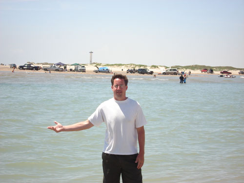
11 June, 2007 at 12:45 am
You can right click and view-image, to see these in much bigger finer detail.
11 June, 2007 at 7:43 am
I grew up there during the 50’s (Brownsville, Texas). There is a 20 mile stretch of beach from the mouth of the river to where Padre Island begins, and is marked there by a row of concrete blocks called “the jetties”.
That 20 mile stretch of beach is called “Boca Chica”, and there is one road going to it from near the Brownsville Airport – you would have pasted by a small stone marking the last battle of the civil war (the battle of Palo Alto), which took place after Lee’s surrender but before the confederates heard about it.
The other side of the river is called “Washington Beach” and there is also a single road to it from Matamoros (Tamualipas, Mexico). During low tides, you can probably wade across, but, as I recall, that was rarely done (never that I actually heard about). It is too easy to just cross over one of the two bridges in Brownsville where hordes of shoppers travel both ways every day, practically uninhibited.
Getting from the U. S. side of the lower Rio Grande Valley to the interior (past Kingsville/Alice) is the problem, because there are only two roads that traverse the very large and desolate King Ranch and there are border patrol stops on both roads. If you came back by car, you were stopped by one of these, and, you can see that smuggling an illegal would not be so easy (count on getting caught in the act).
Boca chica used to be a fun place to hang out when I was growing up – absolutely no commercial establishments for 20 miles and lots of beach and sand dunes to horse around in. I also went to Washington Beach on one occassion (as a guest) and the mexicans there seemed to enjoy that place as much as we enjoyed Boca Chica.
The mass of illegal immigration to the interior is probably not coming here from the lower Rio Grande valley – more likely they are swarming in through Arizona, New Mexico, and southern California – there is really no reason to get wet crossing the river.
11 June, 2007 at 12:53 pm
Full-res photos at:
http://vanguardnewsnetwork.com/images/Padre06rioentersgulf-big.JPG
http://vanguardnewsnetwork.com/images/Padre06alexriogestureright-big.JPG
(Warning: 3MB ea.)
11 June, 2007 at 3:53 pm
A. looks like he is hitchhiking. . .
12 June, 2007 at 8:28 pm
He’s saying, “Join us. We’re the good guys”!